
18.03. – 21.03.2026 – SAVE THE DATE!


The LAC meetings showcase the broad scope of landscape
archaeology research across the globe. These meetings take place every two years under the auspices of the International Association for Landscape Archaeology (IALA). 14 years after the meeting in Berlin (2012), the LAC returns to Germany.
Bamberg’s well-preserved Medieval center with its unique city garden landscape is UNESCO World Heritage. Situated near the spectacular Frankenjura plateau, it became a major cultural, religious, and economic node in Central Europe during the Middle Ages. As such, Bamberg promises to be an excellent base to explore new directions in landscape archaeology – in the city itself, the region of Franconia, and the wider world.

· River and wetland landscapes
· Vertical landscapes
· Populations and demography
· Economies and resources
· Archaeological heritage and valorization of past landscapes
· Non-invasive methods and techniques
· Geospatial analysis
· Big data
With over 500 submitted abstracts,
LAC2026 will be much larger than anticipated!
We are very excited about the great enthusiasm to come
to Bamberg to discuss ancient landscapes.
We have decided to add a third conference day
on Wednesday, 18 March 2026.
This will give as much people as possible the opportunity to present their research.
It will also give some air to the scientific program and more time to discuss.
The opening ceremony and icebreaker will remain on Wednesday.
We will have less ice to break, but all the more to celebrate:
landscape archaeology is a dynamic, multifaceted and thriving field of research!
The Call for Papers extended until 7 November 2025.
The Call for Papers for LAC2026 has been extended to Friday, 7 November 2025, to allow participants more time to submit abstracts for oral and poster presentations.
We look forward to your proposals!
The notifications of paper acceptance are expected by 30 November 2025.
Please include in your abstract:
DEADLINE: 07 November 2025
We invite proposals for sessions on the main topics of the LAC 2026 conference.
The Call for Sessions closes on Friday, 18 July 2025.
The following paper categories are welcome:
· Regular sessions
with normal oral presentations of 15 minutes + 5 minutes discussion + poster presentations
· Pitch / PechaKucha
sessions with short oral presentations of 5 minutes (pitches) or 6 minutes 40 seconds (20 slides, 20 seconds each; PechaKucha format)
· Round tables
with a keynote and discussion; either open or with invited guests
Each session has a minimum of 2 organizers.
The session proposal consists of:
· Names + affiliation of the organizers
· Email of corresponding organizer
· Type of session (regular, pitch, PechaKucha, round table)
· Title: max. 20 words
· Text: max. 200 words
· 3-5 keywords
Organizer: Axel Posluschny (Keltenwelt am Glauberg), Susan Curran (The Discovery Programme),
Jürgen Landauer (CAA Germany), Simon Maddison (Institute of Archaeology, UCL),
Žiga Kokalj (Slovenian Academy of Sciences and Arts), Giacomo Fontana (Texas Tech University),
Nejc Čož (Slovenian Academy of Sciences and Arts), Anthony Corns (The Discovery Programme)
Keywords: Archaeological landscapes, Machine Learning, Remote sensing data
Airborne Laser Scanning (ALS)/Lidar and other remote sensing technologies are revolutionizing the way we document and interpret archaeological landscapes. When combined with machine learning—a dynamic field within artificial intelligence—these datasets unlock new possibilities for detecting, classifying, and understanding subtle archaeological features such as ancient settlements, roads, and earthworks. Machine learning models (MLMs) can rapidly analyze vast amounts of topographic and aerial imagery, revealing patterns and sites that traditional methods might overlook. However, integrating MLMs into landscape archaeology presents a series of challenges and opportunities.
Key considerations include ensuring data quality and consistency from diverse sources, selecting optimal preprocessing and visualization techniques for training models, and tailoring algorithms to different landscape types and research questions. The transferability of models across regions, managing false positives, and designing efficient human-in-the-loop verification workflows are critical for practical application. Additionally, the development of user-friendly, open-source software tools and FAIR (Findable, Accessible, Interoperable, Reusable) workflows is essential for sustainable and inclusive research.
This session invites contributions that address these technical, methodological, and practical questions, fostering a dialogue on best practices and innovative solutions for harnessing machine learning in the exploration of archaeological landscapes
Organizer: Florian Hirsch (Brandenburgische TU Cottbus-Senftenberg),
Holger Schweitzer (CifA – Institute for Archaeologists)
Keywords: Soil landscape, Geoarchaeology, Large linear infrastructure projects
New linear infrastructure projects are essential for achieving the energy transition in Europe. The construction of these projects involves comprehensive surveys across various disciplines, such as archaeology, geoarchaeology, and soil science, to meet the requirements of the approval process.
For instance, ongoing construction projects in Germany are uncovering new insights into past landscapes and archaeological heritage. The linear nature of these projects, often spanning several hundred kilometers, offers a unique spatial perspective that connects neighboring landscapes, soils, and soil archives.
Additionally, since these projects are typically located outside urban areas, they provide opportunities to survey regions that have not been extensively studied before.
However, the surveys conducted alongside these construction projects also highlight challenges, including legal guidelines, technical standards, the need for rapid interdisciplinary coordination, and time pressures on construction sites.
In this session, we aim to bring together recent findings from various disciplines involved in large-scale infrastructure projects, as well as the challenges, opportunities, failures, and successes experienced. The session will explore the hidden potential of interdisciplinary studies and the synergistic effects they can bring to future linear infrastructure projects over the next decade.
Organizer: Uri Davidovich (Institute of Archaeology, The Hebrew University of Jerusalem),
Micka Ullman (School of Archaeology and Maritime Cultures, University of Haifa)
Keywords: Vertical Landscapes, Liminality, Adaptation, Extreme Archaeology, Cognitive Challenges
This session aims to offer cross-cultural perspectives on human activity patterns in, and perception of, ‘true’ vertical landscapes, i.e., landscapes that require negotiating vertical obstacles (cliffs, underground shafts, chasms, tall trees, etc.). These landscapes, which abound in many different regions around the globe, may evoke fear, stress, and a great sense of vulnerability, but, at the same time, also thrill, challenge, and heightened awareness. In tandem, operating in these landscapes commonly requires substantial effort as well as designated technologies (ropes, ladders, scaffolding), thus confronting the human body-mind with both physical and cognitive adversity.
In this capacity, vertical obstacles may often function as liminal spaces that require advanced skills and innovative solutions, while also offering unique possibilities and affordances.
This session invites contributions that examine archaeological and ethnographic case-studies of human use of sheer spaces, that reflect on the dynamic interactions between humans and these unique landscapes. Within this framework, we would like to engage with several key questions: How were human activities embedded in, shaped by, or transformed vertical landscapes? How did people respond to the challenges—physical, cognitive, and technological – imposed by these landscapes? And, ultimately, what motivated human engagement with these arenas?
Organizer: Agostino Sotgia (University of Groningen), Dario Monti (UC Louvain),
Elena Scarsella (Barcelona Supercomputing Center)
Keywords: Marginal landscape, Economic integration, Resource use in challenging environments, Longue durée, Environmental and social interplay
This session aims to be a hub for discussing the significance of economic role in landscapes often considered marginal, such as wetlands, highlands, and other environmentally challenging areas, through the use of historical and archaeological perspectives on the longue durée. While traditionally perceived as peripheral due to their remoteness, limited accessibility or unequal resources distribution, these landscapes are increasingly recognised as dynamic economic spaces shaped by local communities and embedded within larger territorial systems.
We therefore welcome in this session papers applying a wide range of methods—including archaeological survey and excavation, historical and environmental analysis, archaeometry, and computational modelling— aiming to investigate how these landscapes were used, structured, and valued economically.
Particular attention will be given to the interplay between environmental features and social organisation, and the roles played by both local agents and external powers in the economic integration of these territories.
The session deliberately sets no specific chronological or geographical boundaries, seeking instead to foster dialogue across different regions and periods. By encouraging comparison between diverse case studies, we seek to identify recurring patterns, evaluate the variability of economic strategies in so-called marginal contexts, and reflect on the most effective methodologies for their investigation.
Organizer: Pière Leon Frederiks, Kira Raith, Svea Mahlstedt,
Moritz Mennenga (Lower Saxony Institute for Historical Coastal Research)
Keywords: coastal landscape, coastal settlements, sea-level, adaptation, marine trade
A key focus in landscape archaeology lies in researching the interaction of past human communities and their surrounding environment. This complex interaction can be observed particularly in coastal areas. Coastal landscapes have always been attraction and challenge to human habitation. From hunter-gatherers at postglacial sea-level rise across terp settlements and marine trade and communication structures we see manifold approaches to coastal landscapes through time.
In this session we would like to explore human adaptation to tidal and non-tidal coasts between reaction and early hydraulic engineering. We focus on fluvial estuaries, drowned or covered landscapes as well as on islands including the idea of a seascape archaeology worldwide. We welcome contributions on case studies as well as on research methods and theoretical backgrounds.
Organizer: Ylenia Paciotti (University of Genoa), Carlo Citter (University of Siena)
Keywords: Transitions, Climate Change, Multidisciplinarity, Methods, Human-Environment Interactions
Contemporary landscapes are the result of ongoing transformations driven by both environmental and human influences. This continuous evolution has compelled human communities to adapt and reshape their surroundings in response to changing needs.
While such transformations are expected to be particularly noticeable during transitional periods, they are not always clearly reflected in the material record. This is partly because historical transitions are often framed according to the chronology of written sources, whereas archaeological evidence follows its own distinct temporal logic.
The session “Landscapes of Changes” seeks to document the transition from the medieval to the modern period, exploring how this process unfolded across various contexts.
A particular focus is placed on understanding the impact and extent of emerging rural capitalism in shaping these changes. We invite contributions that present specific case studies and offer methodological insights arising from them.
Given the complexity of these transformations, research must adopt multi- and transdisciplinary approaches, drawing on diverse types of data. This session will examine how landscapes in Mediterranean and European regions evolved between the 14th and 19th centuries, while also engaging with the theoretical frameworks used to study these developments.
Organizer: Francesca Chelazzi (University of Glasgow / University of Pisa), Kirsten Hopper (Durham University),
Stefania Fiori (Kiel University), Lisa Doro (University of Turin)
Keywords: Mountain Landscapes, Decolonising, Community Engagement
Traditional perspectives on mountainous landscapes, which still influence research agendas, have often characterised them as marginal or peripheral spaces, which undervalues the historical complexity of upland societies, and the modern knowledge of local communities.
This session aims to explore the problematic application of standardised interpretative and methodological tools that often fail to suit the ecological and cultural complexity of mountain environments; the modern conception of uplands as harder to reach, more rural, and more pristine spaces, which can oversimplify local knowledge and reduce it to „primitive insight“; and the very real need to challenge colonial legacies and practice archaeology in more equitable terms of access to resources and knowledge.
We encourage participants to share case studies and theoretical reflections (PechaKucha style, 5-min presentations) that confront disciplinary blind spots, propose alternative epistemologies, and reconceptualise mountain landscapes not as „peripheries“ but as generative centres of meaning, memory, and cultural negotiation. Submissions could reflect on questions such as:
• How does your research challenge traditional narratives?
• What alternative methods/approaches have you used?
• What role do local communities play?
Presentations will be followed by a discussion (guided by pre-circulated questions). Attendees will be encouraged to engage throughout with interactive questions.
Organizer: Iris Nießen (University of Tübingen / Leipzig University), Martin Offermann (Leipzig University),
Jens Schneeweiß (LEIZA), Johannes Schmidt (Leipzig University / TU Dresden), Alexander Voigt (University of Bamberg)
Format: regular session; oral presentations of 15 minutes
Keywords: Fluvial Landscape Archaeology, Settlement Dynamics, Human–Environment Interaction,
Geomorphological Processes, Fluvial Anthroposphere
Floodplains rank among the most dynamic cultural landscapes globally, shaped by the constant interplay of river activity, climate variability, and human settlement. This session seeks contributions that explore the development, distribution, and transformation of settlements in floodplain contexts across diverse time periods, from the Palaeolithic to the modern era. We especially welcome case studies and comparative approaches that examine the complex interactions between human agency, environmental change, and hydrological systems, including the use of floodplains for agriculture, resource exploitation, and energy.
Despite a wealth of regional studies, a comprehensive understanding of floodplain settlement dynamics on a supra-regional scale remains a significant research gap.
This session aims to address this by bringing together perspectives from archaeology, geomorphology, and environmental history. We encourage presentations that investigate settlement patterns, land use, water management, and hydro-engineering practices, as well as the archaeological materiality of these processes.
Contributors are also invited to reflect on methodological challenges and latest developments in fluvial archaeology and to discuss the concept of the “Fluvial Anthroposphere”—that is, when, how, and why humans began to leave a lasting imprint on floodplain environments. This session fosters interdisciplinary dialogue and seeks to unlock the potential of floodplains as cultural and environmental archives.
Organizer: Michele Abballe (Ca’ Foscari University of Venice), Francesca Chelazzi (University of Glasgow / University of Pisa), Alessio Palmisano (University of Turin), Dan Lawrence (Durham University)
Format: Regular session; oral presentations of 15 minutes
Keywords: archaeological sites, settlement patterns, frequency distributions of radiocarbon dates, archaeodemography, computational archaeology
Reconstructing past human population dynamics from archaeological evidence has been a central focus of the discipline for over a century. Archaeodemographic estimates were traditionally based on the size and number of urban settlements, and of burials. However, growing attention has been directed towards rural settlement patterns, with increasingly sophisticated modelling techniques refining the interpretation of raw site counts and sizes. Meanwhile, innovative approaches to radiocarbon date frequency distributions have been broadly applied to prehistoric and protohistoric contexts. The diversity of approaches adopted has led to considerable debate, especially regarding the comparability of demographic signals, yet there is broad consensus on the value of multiproxy approaches for inferring past demographic trends.
These offer powerful insights into shifts in settlement systems, cultural transformations, and human adaptive strategies in response to environmental and climatic changes, among other factors.
We welcome papers exploring the latest advances in archaeodemographic research on three key aspects:
– innovative methodological approaches, particularly those involving advanced statistical applications;
– applied case studies employing (multiproxy) archaeological datasets to generate robust and nuanced reconstructions of demographic trends across regions and chronological frameworks;
– critical reflections on how to integrate different proxies and external datasets to produce robust interpretations of causal relationships across multiple scales.
Organizer: Ayaka Nguyen (University of Tübingen / Landesamt für Denkmalpflege Stuttgart),
Sara Saeidi (Landesamt für Denkmalpflege Stuttgart), Stefan Dreibrodt (Landesamt für Denkmalpflege Stuttgart)
Format: Regular session; oral presentations of 15 minutes; posters
Keywords: Rapid Environmental Change, Human-Environmental Interaction, Palaeoecological Reconstruction, Landscape Archaeology, Biodiversity
This session invites contributions exploring short-term events in human-environmental systems during the Holocene, as recorded in sedimentary and paleoenvironmental archives. Natural events such as volcanic eruptions, floods and fires, as well as human-induced disruptions like conflicts, pandemics, and famines, can trigger abrupt shifts in land use and profoundly reshape landscapes, settlements, and economies. These events often create dynamic feedback loops, leading to societal transformations; however, their long-term effects on the landscape remain poorly understood.
We seek to foreground episodes of rapid environmental transformation and their sudden impacts on the landscape, as well as the resulting ecological effects on both aquatic and terrestrial habitats.
How are these processes recognised or overlooked in sedimentary and palaeoecological records? Can we effectively differentiate human influence signatures from natural hazards? What methodological innovations allow for the detection, analysis, and interpretation of such subtle changes?
We welcome contributions and case studies using high-resolution palaeoecological data, archaeological records, experiments, geospatial analysis, and sedimentary proxies that highlight short-term landscape processes. This session aims to reframe questions of scale, visibility, and causality in landscape archaeology by focusing on episodic events rather than gradual change, emphasising the dynamic and sometimes disruptive interaction between human agency and environmental unpredictability.
Organizer: Parth R. Chauhan (Indian Institute of Science Education and Research) and
Prabhin Sukumaran (Charotar University of Science and Technology)
Format: Regular session; oral presentations of 15 minutes; posters
Keywords: Quaternary Adaptations, Paleoenvironmental Change, Hominin Dispersal, Dynamic Landscapes
This session explores the dynamic interplay between environmental transformations and biocultural responses during the Quaternary period. Spanning over 2.5 million years, the Quaternary witnessed profound climatic fluctuations and geomorphic changes ranging from glacial-interglacial cycles to evolving fluvial, aeolian, and tectonic landscapes. These shifting ecologies shaped the survival, movement, and adaptation strategies of floral, faunal, and hominin populations across diverse regions. We invite contributions that engage with these themes through multidisciplinary approaches, including geoarchaeology, paleoclimatology, paleoecology, zooarchaeology, and paleoanthropology.
How did hominin groups respond to shifting resource landscapes and environmental constraints? What patterns of mobility, dispersal, and technological innovation can be linked to ecological pressures? What do sedimentary, archaeological, and fossil records reveal about population resilience and behavioral flexibility? From local site-level analyses to broad-scale regional syntheses, this session aims to integrate global perspectives and foster dialogue across disciplinary and cultural contexts. Submissions from all geographic regions and cultural settings are encouraged.
Organizers: José Abellán Santisteban, Ylenia Paciotti (University of Genoa)
Format: Regular session; oral presentations of 15 minutes; posters
Keywords: Mountain landscape, Interdisciplinary, Landscape dynamics, Multiscalar analysis, Cultural landscapes
Mountain landscapes have long been inhabited and modified by human communities, leaving behind a complex legacy of archaeological traces, environmental markers, historical sources, and living traditions. Rather than marginal spaces, mountains are ecological frontiers where human-environment relationships unfold over time.
This session adopts a transdisciplinary approach to mountain areas as dynamic, multilayered landscapes. By bringing together Archaeology, History, and related disciplines, we seek to explore the practices, transformations, and meanings that have shaped these regions across different scales.
We invite case studies from diverse contexts, especially those that integrate a multi-approach (material, ecological-ambiental, textual) or reflect on methodological and theoretical challenges in studying “mountainscapes.”
Special attention is given to contributions that advance innovative approaches or frameworks.
The session encourages critical dialogue around key questions:
– How can mountain landscapes serve as conceptual spaces in landscape archaeology?
– What can their ecological and cultural dynamics reveal about land use and continuity/discontinuity?
– How can transdisciplinary perspectives move us beyond traditional dichotomies (cultural/natural, central/marginal, local/global)?
By framing mountain landscapes as central arenas of inquiry, we aim to contribute to wider debates and promote both empirical and conceptual innovation in landscape archaeology.
Organizers: Ralf Vandam (Free University Brussels), Soetkin Vervust (Free University Brussels),
Axel Cerón González (Free University Brussels), Antony Brown (Arctic University of Norway)
Format: Regular session; oral presentations of 15 minutes; posters
Keywords: Terracing, Land-use history, Soil archives, Paleoenvironmental reconstructions
Terraced landscapes are iconic expressions of vertical human-landscape interactions. Found across diverse topographies and timescales, they embody long-term socioecological engineering: mitigating erosion, managing water, stabilizing slopes, and enhancing agricultural productivity. Yet terraces are more than functional structures — they are stratified archives of human intention, environmental response, and social transformation. This session invites contributions that explore terraced landscapes as sites of knowledge, adaptation, resilience, or collapse.
We welcome papers that examine their construction, use, maintenance, and abandonment, as well as their embedded environmental signals — from soils and sediments to flora, fauna, and hydrology. Multi-scalar and interdisciplinary approaches are encouraged, especially those integrating archaeology, environmental history, geomorphology, soil science, paleoecology, or remote sensing. Particular interest goes to diachronic analyses that reveal how terracing operated — successfully or not — as a cultural strategy for inhabiting and transforming dynamic vertical landscapes across the globe.
Organizers: Ralf Kilian (University of Bamberg), Dennis Mitschke (University of Bamberg),
Martin Michette (University of Oxford), Suramya Bansal (ACCE), Pia Kastenmeier (Fraunhofer IBP),
Katrin Wilhelm (University of Oxford)
Format: Round table with invited speakers
Keywords: Cultural heritage, Landscape conservation, Environmental change, Capacity building, Pedagogy
The “Academy of Conservation and Care for the Environment” (ACCE) is an emerging initiative that uses sites at the intersection of natural and cultural heritage to investigate the entangled relationships between cultural heritage, environmental change and local economies. ACCE brings together early-career researchers and practitioners from diverse fields, including archaeology, heritage, conservation, architecture and environmental sciences to facilitate knowledge creation, develop transdisciplinary skills and build capacity in integrated management.
This Round Table will address key themes and activities from the inaugural 2024 edition of ACCE, held in Pompeii and the Amalfi Coast. These focused on traditional land-use practices (e.g., olive harvesting, terraced agriculture), valorisation of archaeological sites and cultural landscapes, and response to local economic and environmental challenges.
We engaged with stakeholders, ranging from grassroots organizations to regional authorities, to establish multidirectional knowledge exchange and develop workshops for teaching and embedding new skills and strategies.
We will invite participants and partners from the inaugural academy to reflect upon these learnings and look towards the future of the program.
Rather than separating natural and cultural heritage, ACCE advocates for their integrated management. Heritage can thereby provide a platform for linking diverse knowledge systems and upscaling practices for general climate change adaptation.
Organizers: Sjoerd Kluiving (IALA, Free University Amsterdam), Rebekka Dosche (IALE, University of Genoa),
Nik Petek-Sargeant (IALA, University of Cambridge), Valentina Pescini (IALE, Catalan Institute of Classical Archaeology), Anneli Ekblom (IHOPE, Uppsala University), Paul Lane (University of Cambridge),
Giovanna Pezzi (IALE, University of Bologna), Bennie Shen (University of Cambridge),
Marianna Biró (IALE, HUN-REN Centre for Ecological Research, Budapest),
Matthew Davies (University College London / University of Cambridge)
Format: Round table with keynote; short presentations
Keywords: Human-environment interactions, Long-term processes, Land use legacies, Methods of landscape archaeology
Human impacts on the environment have a long history and understanding. This may bring landscape archaeology and landscape ecology closer in a view to have a robust background and a proper perspective of the ongoing environmental changes. Many questions and challenges are easier to handle by bridging the two disciplines. This joint session of landscape archaeologists of IALA (International Association of Landscape Archaeology), landscape ecologists of IALE (International Association of Landscape Ecology) and researchers from IHOPE (Integrated History and Future of People on Earth Research Network) brings together researchers to learn about each other’s methods and approaches and to identify common research interests and the possibilities for collaboration.
The session will explore the effects of land-use and land management practices, as well as natural events over the past millennia.
Topics may include the impacts of historical drainage systems and water regulations, major climatic periods and epidemics, volcanic eruptions, or the use of fire for pastoral or agricultural purposes. Discussions will also include the role of wild and domesticated animal movements, agro-silvo-pastoral systems across centuries, and the legacies of other forgotten land-use practices that still shape today’s landscapes and habitats. Adapting to future landscape processes requires the integration of natural and social sciences.
This session will host inspiring debates on how the historical experiences of the two disciplines can be used to plan for a sustainable future with humans present in an improved biodiversity.
Invited talk: Christian Isendahl et al (University of Uppsala)
Organizers: Jessica Meyer, Burkart Ullrich (Eastern Atlas GmbH & Co. KG, Berlin)
Format: Regular session; oral presentations of 15 minutes; posters
Keywords: power lines, geophysical prospection, big data
The transition to renewable energies requires extensive construction in the supply infrastructure. The large-scale interventions for underground cable routes affect the protection of cultural assets throughout Germany and Europe.
Non-destructive geophysical prospection methods are used for the early assessment of archaeological potential along planned routes. Depending on the legal situation, experience, expertise and preference, the regional approaches to implementation vary greatly.
This session will present and discuss challenges and solutions for dealing with archaeological and other anthropogenic remains in the ground from the different perspectives of network operators as clients, prospecting and excavation companies as service providers and contractors, and heritage departments as supervisory authorities.
Contributions on the following topics are welcome:
Organizers: Sjoerd Kluiving (Free University Amsterdam),
Pilar Diarte-Blasco (Institute of History, Dept. of Archaeology and Social Processes, Madrid),
Joris Aarts (Free University Amsterdam), Anneli Ekblom (Uppsala University), Wolfgang Alders (New York University),
Thomas Meier (University of Heidelberg), Paul Lane (University of Cambridge)
Format: Round table
Keywords: Future of research and education, Polycrisis and Anthropocene, Community archaeology, Biocultural heritage
Organizers: Anna Schneider (BTU Cottbus-Senftenberg), Jens Schneeweiß (LEIZA), Max Grund (University of Kiel),
Oliver Nelle (Landesamt für Denkmalpflege Stuutgart), Koen Deforce (Ghent University)
Format: Regular session; oral presentations of 15 minutes; posters
Keywords: land use legacies, historical forest use, woodland archaeology
Forest areas are key elements of cultural landscapes and often preserve valuable but underexplored geoarchaeological records. Historical forest uses, such as charcoal and tar production, have left distinctive traces in soil and microrelief. These, along with remains of former agriculture or settlement, are often well preserved due to limited surface disturbance in woodlands. As such, forests serve as archives of human activity, land-use history, and environmental change.
However, these cultural relics are endangered by the increasing use of forestry machinery, especially as forests are restructured in response to climate change.
Advances in remote sensing have improved the detection of such features, but meaningful interpretation requires careful integration with archaeological, historical, ecological, and pedo-sedimentological data.
This session invites contributions that investigate the cultural and environmental legacies of forest use (including the significance of traditional forest by-products such as potash, tar, resin, charcoal) and past land-use changes, and the ecological impacts of past human interventions. We specifically welcome interdisciplinary approaches combining geospatial analysis with fieldwork and archival sources. The session aims to advance our understanding of long-term human-landscape interactions in forested areas and to highlight their relevance for today’s forest and cultural heritage management.
Organizers: Kerstin Kowarik and Valentina Laaha (Austrian Archaeological Institute at the Austrian Academy of Sciences)
Format: Regular session; oral presentations of 15 minutes; posters
Keywords: Mountain Archaeology, Vertical landscapes, Geoarchaeology, Sediments, Multi-Proxy
Vertical landscapes present distinct challenges for research into the deep past of human-environment interactions. In particular, low artifact densities combined with limited accessibility complicate both fieldwork and the application of analytical methods.
Recent developments in field instrumentation and the substantial analytical advances in bio- and geoarchaeology represent a game changer for research in mountainous landscapes. In particular, soils and sediments hold tremendous potential to explore human-environment interactions in these environments. Assessing how to best access these valuable and sensitive archives is a critical and urgent task. The application of geoarchaeological research frameworks in these settings represent a rapidly emerging field.
Analytical techniques like soil geochemistry, multi-omic approaches, micromorphology, and geophysical prospection offer significant potential for understanding not only local site formation processes but to reconstruct landscape scale human-environment systems in mountain regions.
We invite contributions exploring geoarchaeological research in vertical landscapes, with particular emphasis on, but not restricted to:
• Multi-proxy analyses of mountain soils
• Soil geochemistry in mountain contexts
• Geophysical prospection in vertical landscapes
• Micromorphology on mountain soils
• Emerging theoretical and methodological frameworks
• New research questions enabled by recent advances
Organizers: Stefanie Berg, Philipp Hagdorn and Marc Miltz (Bayerisches Landesamt für Denkmalpflege)
Format: Regular session; oral presentations of 15 minutes; posters
Keywords: Geospatial analysis, Archaeological data, Heritage management, Remote sensing, Preventive protection
The increasing availability of geospatially referenced archaeological data through digitization and open data initiatives has greatly expanded analytical capabilities in heritage management. The integration of remote sensing enables advanced geospatial analyses that improve understanding of site distribution and characteristics. These methods help assess the probability, type, and extent of archaeological sites, detect previously undocumented ones, and trace landscape changes over time.
As key elements of preventive heritage management, they support informed decision-making and reduce the risk of heritage loss.
This session invites contributions that highlight the analytical use of geospatial and archaeological big data for cultural heritage protection. Relevant topics include:
Applications of geospatial analysis in archaeological heritage management Use of artificial intelligence for interpreting archaeological data Spatial assessment techniques for site protection and preservation.
Organizers: Luigi Pinchetti and Valerie Palmowski (University of Bonn)
Format: Regular session; oral presentations of 15 minutes; posters
Keywords: Power Relations, Settlement Patterns, Spatial Analysis, Rural Agency, Heterarchy
This session explores how a diachronic approach to landscapes as multi-layered social spaces can offer new insights on power dynamics in rural contexts in the longue durée. It aims to understand hierarchies within broader landscape dynamics, recognising that the establishment of structures of power (political, military or religious) underwent local negotiation processes, and wasn’t solely a top-down process.
Transformations in settlement patterns illustrate how communities accepted, contested or reinforced the status quo within complex networks of power. Through multi-temporal case studies, we highlight how the spatial expression of identities and power materialise, whether through new burial or religious sites, the emergence of new administrative centres, or shifts in communication networks.
The session encourages participants to engage with the concept of heterarchy, a theoretical framework in which vertical hierarchies and horizontal networks coexist, offering new perspectives on how power relations shaped settlement organisation. In fact, different power sources coexisted in the landscape, creating intertwining networks to which the rural population correlated in various ways depending on situational contexts.
We particularly welcome contributions that are based on a diachronic and multidisciplinary landscape archaeological approach, including – among others – archaeological survey, spatial approaches, bioarchaeological data. We welcome all contributions from prehistory to present.
Organizers: Eduardo Herrera-Malatesta (University of Bonn), Jesus García-Sánchez (Spanish School of History and Archaeology in Rome (EEHAR-CSIC), David González-Álvarez Institute of Heritage Sciences,
Spanish National Research Council (INCIPIT-CSIC)
Format: Regular session; oral presentations of 15 minutes; posters
Keywords: Geopolitics, Territoriality, Mobility, Decolonization, Resilience
This session examines how geopolitical landscapes, seen as spatial expressions of power, control, and resistance, have influenced and been influenced by human activity over time. We welcome contributions that analyze historical configurations of geopolitical space and contemporary frameworks that reflect on them. From territoriality, frontiers, and mobility control in ancient societies to modern stories of statecraft and border-making, the session aims to critically explore how archaeologists, historians, and social scientists understand the political aspects of landscapes.
The session focuses on methodological innovations, such as GIS-based modeling, spatial network analysis, and simulations, that enable us to track territorial strategies and political imaginaries in the archaeological record, and how these geopolitical aspects mediate the shaping of socioenvironmental relations between local communities and their surrounding landscapes.
It also adopts theoretical approaches from decolonial, Indigenous, and critical geopolitical perspectives, challenging inherited paradigms and Eurocentric spatial epistemologies.
We are particularly interested in research that engages with questions of authority, resistance, sovereignty, where landscape is considered from its material and symbolic interconnections.
We welcome case studies, theoretical reflections, and methodological advances that engage with the complex and contested nature of geopolitical landscapes.
Organizers: Davide Schirru (Musei Nazionali di Cagliari), Matteo Alessi (Sapienza University of Rome),
Alessandro Vanzetti (Sapienza University of Rome), Emily Holt (Cardiff University)
Format: Regular session; oral presentations of 15 minutes; posters
Keywords: GIS, Spatial modelling, Archaeological Theory, Mediterranean
Organizers: Aydin Abar (University of Innsbruck),
Elena Silvestri (Soprintendenza per I beni e le attività culturali, Provincia Trento)
Format: Regular session; oral presentations of 15 minutes; posters
Keywords: resources, resource-scape, harsh environments, mountain archaeology, resource archaeology
Landscapes emerge through the dynamic interplay of biotic agents, environmental conditions, and human social construction. This is especially true for potential resources—elements of the environment that gain meaning and value through cultural, economic, and symbolic practices. In recent years, this perspective has gained traction in disciplines such as anthropology (Varfolomeeva 2023), archaeology (Stöllner et al. 2024), human geography (Amenta & Attademo 2023), and beyond.
Resources can profoundly shape communities, as demonstrated by seafaring and mining from prehistory to the present. They serve as focal points of hope and fear and reflect moral, and spiritual frameworks, often articulated through religious or magical engagements with the environment.
Resources draw people into unfamiliar or harsh environmental conditions and are central to migrations, and social change. At the same time, human engagement with resources has the capacity to deeply alter ecosystems, sometimes irreversibly.
This session invites contributions that engage with the concept of the resource-scape. We seek to discuss its analytical value, potential applications, and conceptual limitations. Presentations may draw on ongoing research, we do not privilege any particular chronological period. We particularly welcome contributions that engage critically with the concept of the resource-scape, whether through theoretical reflection, case studies, or comparative approaches.
Further reading:
Amenta, L. and Attademo, A., 2023. Periurban costal landscape: A method to identify and map resource-scapes.
Territorio della Ricerca su Insediamenti e Ambiente, [e-journal] 30(1), pp. 95–114. http://dx.doi.org/10.6092/2281-4574/10103.
Stöllner, T., Aali, A., Boenke, N., Davoudi, H., Draganits, E., Fathi, H., Franke, K. A., Herd, R., Kosczinski, K.,
Mashkour, M., Mostafapour, I., Nezafati, N., Öhrström, L., Rühli, F., Saeidi, S., Schapals, F., Schimerl, N.,
Sikorski, B. and Zifar, H., 2024. Salt Mining and Salt Miners at Talkherud–Douzlākh, Northwestern Iran: From Landscape to Resource-Scape. Journal of World Prehistory. http://dx.doi.org/10.1007/s10963-024-09183-z. Varfolomeeva, A., 2023. Indigenous connections with the resourcescape in the Russian North and Siberia. Globalizations, pp. 1–17. http://dx.doi.org/10.1080/14747731.2023.2171221
Organizers: Markus Fuchs (University of Giessen), Hans von Suchodoletz (University of Jena / University of Leipzig),
Christian Tinapp (University of Leipzig / Saxony Archaeological Heritage Office)
Format: Regular session; oral presentations of 15 minutes; posters
Keywords: Fluvial Environments, Floodplains, River catchments, Slope-floodplain coupling, Geoarchives
Rivers and their environments are important areas in the history of mankind. As rivers provide vital resources such as water, food or energy, and represent important traffic routes, these places have always been privileged areas for their economic use and settlement and have often been a hotspot of cultural development. For this reason, in addition to natural changes, riverine landscapes have always been subject to anthropogenic change, with vegetation or river courses being altered, and infrastructure such as mills, bridges or weirs being installed.
However, it is not only the changes along the river course that need to be considered, but also the changes and activities within the entire catchment such as agriculture, charcoal production or mining had a direct or indirect impact on riverine environments, their societies and socio-political and economical systems. To better understand these feedback mechanisms between humans and the environment, we welcome all geoarchaeological and archaeological contributions dealing with the landscape archaeology of riverine environments and their hinterland, working at different spatial and temporal scales and using different colluvial and alluvial geoarchives, proxies and landscape reconstruction techniques.
Organizers: Viviane Diederich (University of Bamberg), Michael Preusz (University of West Bohemia in Pilsen)
Format: Regular session; oral presentations of 15 minutes; posters
Keywords: boundary, archaeology, landscape, space, material culture, public archaeology
This session focuses on archaeological approaches to landscapes of boundaries – both physical and symbolic spaces that define, divide, or connect territories, groups, and identities. Border areas are places of conflict and encounter, control and exchange, and they leave distinctive archaeological traces. We welcome contributions on archaeological investigations of boundaries in the broadest sense – from fortified limes and hillforts, to natural barriers and communication corridors, to micro-regional boundaries between settlements or cultural groups. Given the long-term transformation of border landscapes, we invite contributions on all historical periods, including the modern era.
Borders influence and shape individuals, societies, and cultures in diverse ways, and often leave traces in cultural memory. Here a public archaeological approach can offer valuable insights, although it may pose methodological challenges.We are interested in how archaeological data can help reconstruct the processes of space definition, trace changes in its perception and function, and reveal how boundaries are manifested in material culture.
The aim of the session is to open a discussion on the concept of „bordering“ in archaeology and to showcase the diversity of methods and interpretations that allow us to understand landscapes not only as places but as dynamic socio-political concepts that affect past and present societies.
Organizers: Andreas Vött (University of Mainz), Thomas Becker (Hessian State Office for Monuments and Sites)
Format: Regular session; oral presentations of 15 minutes; posters
Keywords: Manipulated Water Bodies, Archaeology, Geoarchaeology, Landscape Relics
The functional use of water can be traced back to early human history. Examples of this include the oldest dugout canoes found from the Neolithic period, which clearly indicate the use of waterways as transport routes. However, the adversities of using water can also be repeatedly demonstrated by findings of flooding, which indicate a lack of control over the waterways and an awareness of their potential appearance. In the course of technical development and the intensification of landscape use, ways of controlling waterways
through manipulation and intensifying their use have been developed.
River straightening and artificial canal construction as well as controlled drainage in the form of mill ditches, for example, are findings that bear witness to the development of water management.
However, as archaeological findings in excavations or as preserved elements of the cultural landscape, they are only rarely the subject of research, which is often dependent on monument preservation events or targeted research projects on a specific object. In addition, their preservation or original construction poses difficulties in terms of functional and chronological interpretation. The aim of the session is therefore to approach the phenomenon of water manipulation from the side of archaeology, geoarchaeology or other disciplines, and to highlight and link developments and research approaches.
Organizers: Enrico Giorgi (University of Bologna), Federica Carbotti,
Giacomo Sigismondo (University of Bologna, University of Salento), Veronica Castignani (University of Catania),
Francesca D’Ambola (Sapienza University of Rome)
Format: Regular session; oral presentations of 15 minutes; posters
Keywords: remote sensing; landscape archaeology; field-walking; historical imagery
For a long time, field-walking surveys have been fundamental for the reconstruction of ancient settlement patterns. In recent decades, however, changes in agricultural practices and the associated landscape have significantly reduced the archaeological legibility of the terrain. Moreover, the growing interest in less accessible landscapes, such as uplands and wetlands, often make traditional field-walking surveys unsuitable, limiting both the quantity and quality of data accessible through this approach.
Simultaneously, the development and widespread adoption of remote sensing techniques, from aerial photography to satellite imagery, LiDAR, and geophysical surveys, and the use of multiple historical imagery datasets offer several alternatives capable of providing systematic, integrable, and comparable information.
In light of these shifts, it is legitimate to question the current and future role of field-walking surveys: are they a declining practice, gradually replaced by technological tools, or do they retain an irreplaceable value as a mean of directly observing the diachronic evolution of landscapes and material culture?
This session invites critical reflection on the potentials, limitations, and future of surface surveys, especially in relation to the growing diversification of remote sensing techniques in landscape archaeology.
Should surface surveys be rethought, or are they destined to be definitively abandoned?
Organizers: LAC2026 organizing committee
Format: short presentations, Pecha Kucha format; posters
This general session offers the opportunity to pitch new ideas, methods, strategies, and recent results of your landscape archaeology research to the LAC community.
All topics are welcome.
OPENING CEREMONY
and Icebreaker
Wednesday 18 March 2026, 18.00-21.00
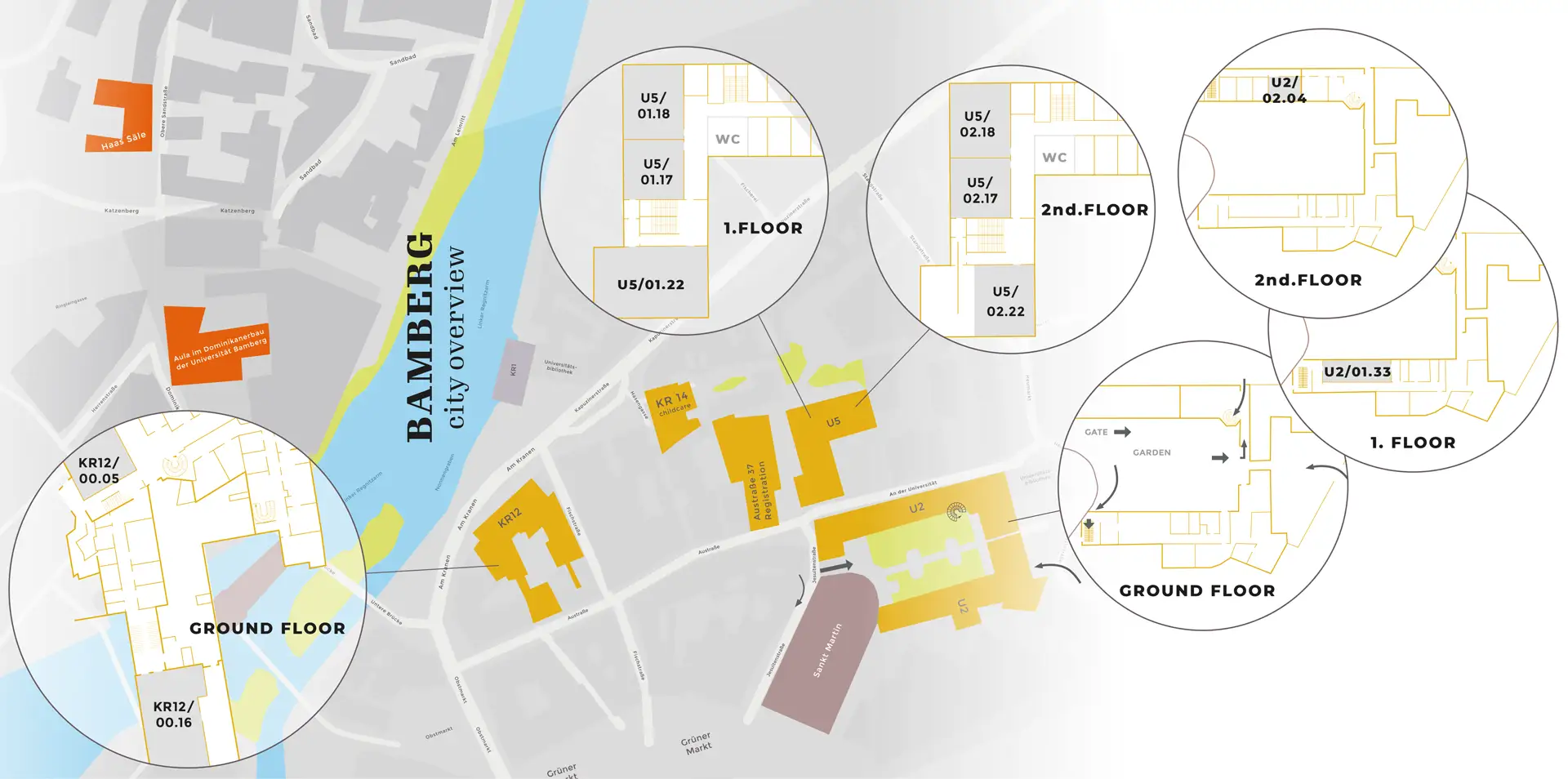
Aula of University of Bamberg, Dominikanerstr. 2
The conference opening and Icebreaker will take place in the former Dominican Church at Dominikanerstr. 2.
The church was built in the late 14th century and has the largest medieval roof in Bamberg.
In the following centuries, it was completely restructured (17th century) and decorated in baroque style (18th century).
After the church was secularized in 1804,
it initially served as a military base and later as the seat of the Bamberger Symphony Orchestra.
Since 1999, it has served as the Aula of the University of Bamberg.
LAC KEYNOTES
Opening Ceremony
Wednesday, 18 March 2026
The keynotes highlight different perspectives on Landscape Archaeology and are intended to make you think about our field at the intersection of the natural sciences and the humanities. We asked two experienced researchers – an archaeologist and a physical geographer – to reflect on the question “what is landscape archaeology”. We hope that their unique viewpoints on the aims, relevance, challenges, and future of landscape archaeology will give you enough to discuss during the Icebreaker.
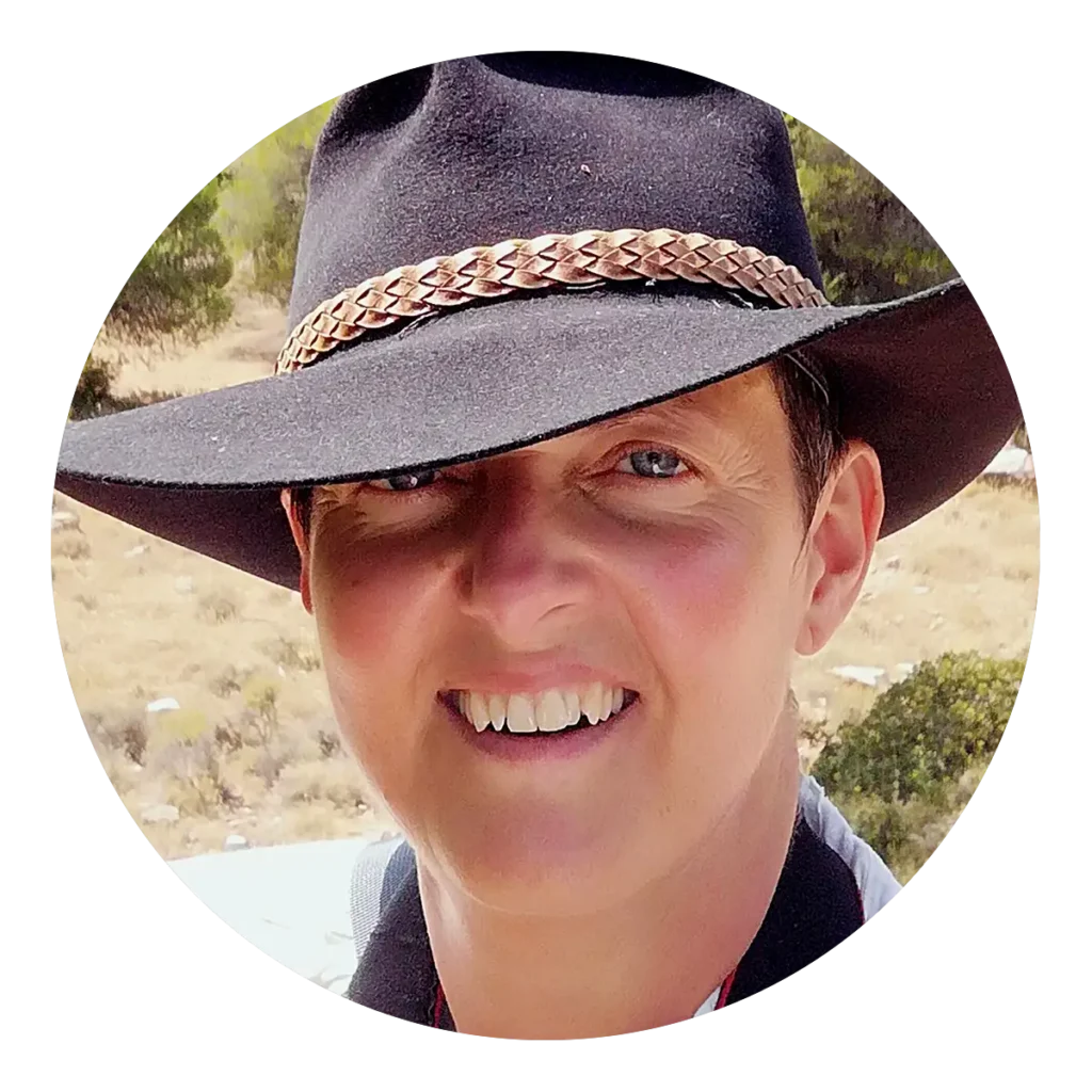
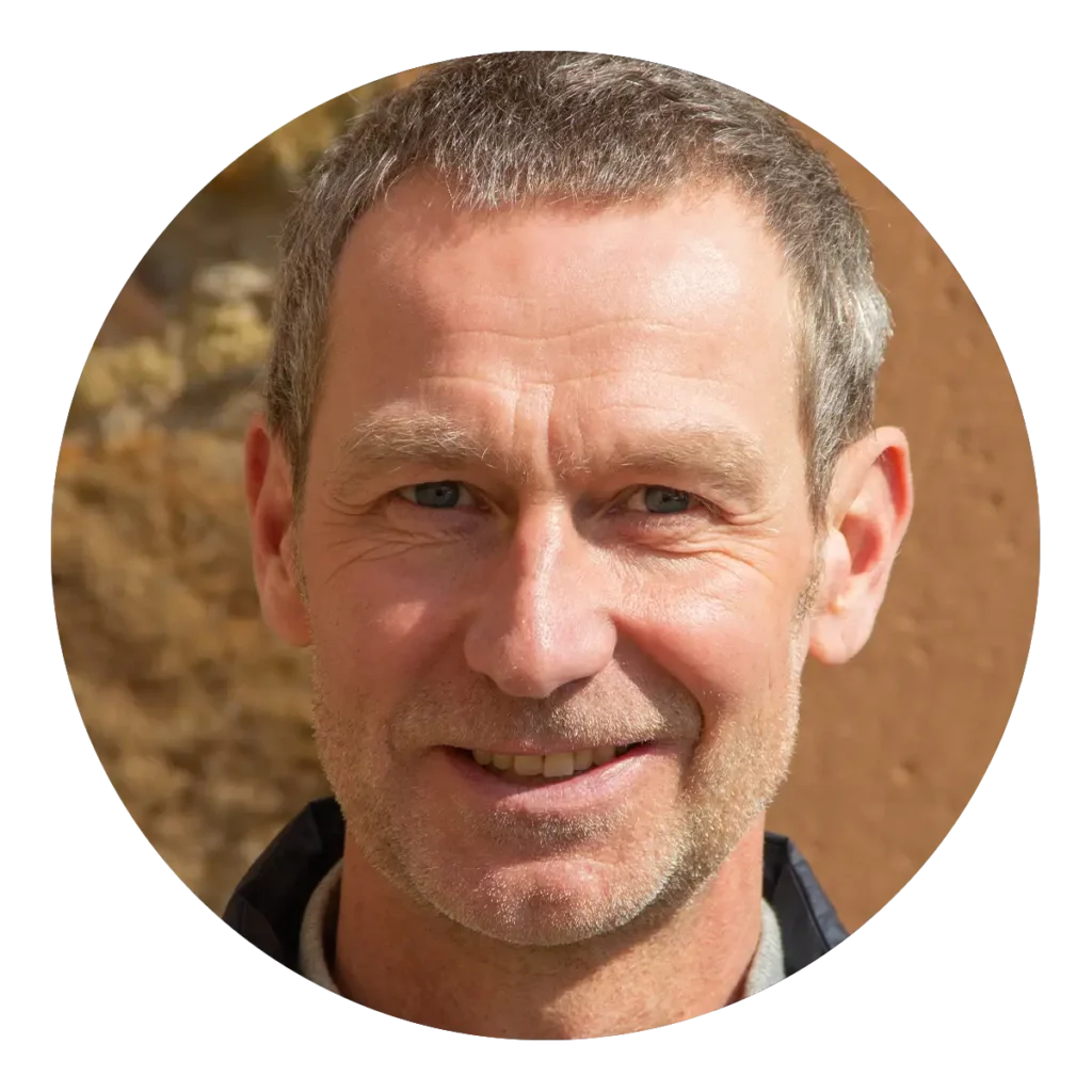
Markus Fuchs is professor at the Department of Geography, Justus Liebig University Giessen (D). As a geomorphologist, geoarchaeologist, and Quaternary scientist, his research focuses on earth surface processes, paleoenvironments of the Quaternary, and the human-environment interactions, especially in fluvial systems. His methodological expertise is on luminescence dating. He is the co-founder of the German Working Group for Geoarchaeology and currently vice president of the German Quaternary Association (DEUQUA).
LAC PARTY
Friday, 20 March 2026, 19:30 – 02.00
Haas Säle, Obere Sandstraße 7
We will celebrate the conclusion of three full conference days in the historic rooms of the Haas Säle.
The building was created in the 17th century by combining two older houses.
Initially it housed a noble family and later the bishops of Bamberg.
Now it is the perfect location for a grand party in the historic rooms
on the second floor and the terrace directly below the cathedral.
The superfunky Bamberg band SoulJam is sure to get the party going
with their signature blend of rap, rock, and funk!
Start: 20.30
From 22.00 onwards,
DJ Earth Find & Wire
will keep you dancing!
Admission is only allowed with a LAC2026 name badge (first come, first served).
The badge entitles you to two free drinks per person. Small snacks will also be served.
Please note: the venue can only be accessed by stairs (2 floors up).
The LAC2026 Poster Prizes will be awarded during the party.
Local organization committee:
Alexander Voigt MA, Dr. Stefanie Becht, Dr. Katja Kothieringer, Dr. Timo Seregely, Dr. Wieke de Neef, Viviane Diederich MA
Dr. Wieke de Neef
Dr. Stefanie Becht
Viviane Diederich MA
Dr. Katja Kothieringer
Dr. Timo Seregély
Alexander Voigt MA
Prof. Dr. Michaela Konrad
Prof. Dr. Andreas Schäfer
Prof. Dr. Rainer Schreg
Peter Attema (Uni Groningen)
Stefanie Berg (BLfD Bayern)
Elisabetta Borgna (Uni Udine)
Francesco Carrer (Uni Newcastle)
Susanna Cereda (Uni Innsbruck)
Andreas Dix (Uni Bamberg)
Nives Doneus (Uni Vienna)
Markus Fuchs (Uni Gießen)
Piraye Hacıgüzeller (Uni Antwerpen)
Julia Meister (Uni Bamberg)
Mara Migliavacca (Uni Verona)
Eleftheria Paliou (Uni Cologne)
Axel Posluschny (Keltenwelt am Glauberg)
Astrid Röpke (Uni Cologne)
Mans Schepers (Uni Groningen)
Deadline for registration for non-speakers:
28 February 2026
Subscribe to our newsletter and stay informed about all the latest updates on the upcoming conference – including speakers, schedules, and special sessions.
Join our mailing list today!